Kauaeranga Valley Trail needs assessment
A needs assessment into community views on the need for a trail in the Kauaeranga Valley has identified a large base of support for a trail, with the majority wanting a trail shared by walkers and cyclists, separate to the road.
The June 2023 needs assessment involved an online survey with 542 responses, three drop-in community sessions which 102 people took part in, and interviews and meetings with stakeholders such as Ngāti Maru, recreational clubs, businesses and schools.
Safety concerns about the narrow, winding Kauaeranga Valley Road with minimal verges were cited, as well as a desire for recreational cycling and walking and tourism benefits.
The needs assessment report recommended the feasibility of a trail in the lower section, Pārāwai to the Swingbridge swimming hole, be investigated first. The report noted that while there are many demands on Council’s limited finances, “prudent planning is required to confirm viability or otherwise for a costly project”.
Background
For a number of years there has been concern about the need for safe access routes for children walking and cycling up Kauaeranga Valley Road and for other leisure users accessing the valley for walking, swimming or cycling.
In 2016 the Visitor Optimisation and Promotion Plan for Thames raised the potential for a new trail in the Kauaeranga Valley.
The Kauaeranga River Valley Trail Advocacy Group been lobbying the Council on a proposal to develop a trail that includes a bridge over the Kauaeranga River, to link Kauaeranga Valley Road to Maramarahi Road and submitted a proposal for the Council’s Long-Term Plan 2021–2031.
Pre-feasibility study
In 2021/2022, Council engaged consultants to undertake a pre-feasibility investigation. The consultants proposed three stages for development, in a trail with a minimum width of 2.5m.
Stage 1: Kauaeranga Valley Road at The Booms to Rennies Access Road – 3.3km
Stage 2: Rennies Access Road to Maramarahi Road, including a swing bridge over the river – 1.5km
Stage 3: Maramarahi Road from the end of Council maintenance to State Highway 25 – 4.5km
The total cost of constructing the three stages is estimated to be $8–10 million.
Advocacy group submission on the Draft 2023/2024 Annual Plan
In a submission on the Draft 2023/2024 Annual Plan, the Kauaeranga River Valley Trail Advocacy Group presented a different proposal for a trail in the Kauaeranga Valley. Rather than a bridge over the river, the updated proposal is for a trail further up the valley than the ford near the Christian Camp.
This change could be due to the river flooding during Cyclone Gabrielle and a reassessment of what might be feasible, given the flooding that occurred up the valley during the 2023 cyclone.
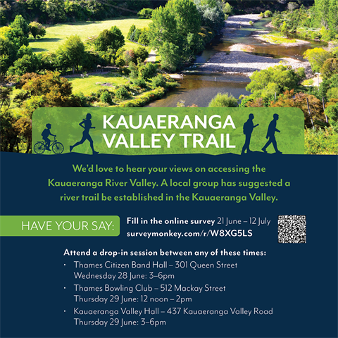
Needs assessment
To understand the current issues and challenges are for residents and visitors, and to gauge support for a trail, community engagement took place in June and July 2023 through drop-in discussion sessions and a survey (open from 21 June–17 July 2023).
The needs assessment involved collecting evidence on the current situation on the issues and trends about the use of the Kauaeranga Valley Road.
What next?
After the needs assessment has been analysed, Thames Community Board will consider whether it is adopted and whether the initiative should proceed to the feasibility stage, including, importantly, whether funding can be mobilised to support a trail.
Want to stay updated on Council projects?
Click here to sign up to our weekly newsletter. We share news, opportunities, events and project updates from around our region.